Transcontinental Railroad Route and Map, 1863 to 1869

The transcontinental railroad map runs from Council Bluffs, Iowa and Omaha, Nebraska in the east to near San Francisco, California in the west, with the two halves meeting at Promontory Summit, Utah on May 10, 1869. The line was authorized by the Pacific Railway Act, signed July 1, 1862, which named Union Pacific and Central Pacific of California as the two companies responsible for building it. Promontory Summit is frequently confused with Promontory Point, a separate location about 35 miles to the south.
Why the line was built
The 1862 Act set out to connect the Missouri River to the Pacific by rail and telegraph, and it directed Union Pacific and Central Pacific to build the line jointly, with Union Pacific created directly by Lincoln's signature on the Act. To make the project financially possible, Congress granted the railroads five alternate sections of public land per mile along the route, and government bonds paid $16,000 per mile of easy terrain, rising to triple that rate for the hardest 300 miles of construction.
The route on the map: Council Bluffs to the Pacific
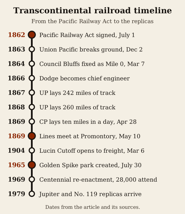
A congressional order of March 7, 1864 settled a key question on the map by officially fixing Council Bluffs as Mile 0 of the line. Lincoln located Union Pacific's actual starting point just across the river near present day Omaha, close to where the company's headquarters still sits.
The choice of Council Bluffs was not arbitrary. Engineer Grenville Dodge had convinced Lincoln that the route should follow the Platte Valley. The city grew along with the railroad in the decades that followed: by 1916 Council Bluffs had become a major rail hub, served by seven railroads and nine passenger depots.

From there, the Act drew the line in two pieces.
Grenville Dodge and the pace of construction
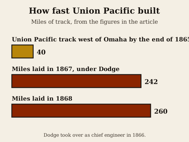
Progress on the Union Pacific side was slow at first. Work began with groundbreaking on December 2, 1863. Even so, the track west of Omaha stretched only 40 miles when 1865 ended. That changed once Grenville Dodge resigned from the Army and became Union Pacific's chief engineer in 1866. Under his direction the pace jumped: crews put down 242 miles of track in 1867, then 260 miles in 1868. Dodge added the role of head of the Land Department in 1869 while still serving as chief engineer, then resigned as an officer of the company in 1870, though he remained on its board of directors until 1897.
Because no single meeting point had been fixed in advance, the two companies kept grading past each other as they raced for government subsidy. Union Pacific and Central Pacific crews graded overlapping miles of roadbed before a meeting point was fixed.
The single most dramatic burst of work came from the other end of the line. On April 28, 1869, Central Pacific crews set a record that still stands, laying more than ten miles of track, ten miles and fifty six feet to be exact, in one day, with a line of roughly 1,000 men advancing the grade at about a mile an hour, as the National Park Service records it.

The golden spike at Promontory Summit
That point turned out to be Promontory Summit, northwest of Ogden, where the line was completed on May 10, 1869.
The ceremony itself is full of small, well documented details. One of the ceremonial spikes, a golden one, was donated by San Francisco construction magnate David Hewes. The rail connection that actually completed the line, however, was made with an ordinary iron spike wired to a telegraph key so the moment could be flashed across the country. When Leland Stanford of Central Pacific and Thomas Durant of Union Pacific each took their ceremonial swing at the spike, both men missed, according to Utah's History to Go. For the photographs, Union Pacific's locomotive No. 119 and Central Pacific's Jupiter were drawn up nose to nose, separated only by the width of a single rail.

After the golden spike: the route changes
The Promontory Summit alignment did not last as the main line forever. According to History to Go, the cutoff ran 102 miles from Ogden to Lucin, including 13 miles of fill and nearly 12 miles of trestle over open water, and it shortened the route by 44 miles at a cost of more than $8 million. Freight trains began using the cutoff on March 6, 1904, with passenger service following about six months later, and the original route over Promontory Summit was effectively made obsolete for main line traffic.
Recognition of the original site came slowly. Golden Spike National Historical Park was not created by the federal government until July 30, 1965, nearly a century after the ceremony.
Once the park was established, it became a focal point for commemorating the event. The 1969 centennial re-enactment at Promontory drew a crowd of 28,000 people, and ten years later, for the 110th anniversary, working replicas of the Jupiter and No. 119 locomotives arrived at the park.

Finding an original transcontinental railroad map
If you go looking for an original transcontinental railroad map rather than a modern reconstruction, the results tend to be archive scans, PDFs and old magazine inserts rather than a single clean document. One good example held by the Leventhal Map Center is a Rand, McNally & Co. map published in Chicago in the 1870s, charting the Union Pacific line from Omaha to San Francisco. It also shows the railroad's land grants, connecting and proposed railroads, and the stagecoach routes that still crossed the gaps in the network. The map doubled as an advertisement, offering 12,000,000 acres of Union Pacific land for sale to settlers along the route, a reminder that the land grant system from the 1862 Act was still actively being worked decades after the golden spike.

Riding the route on Amtrak since 1983
You can still travel much of this corridor by rail, though not on the original Promontory alignment. Amtrak's California Zephyr covers 2,438 miles over three days and two nights, crossing both the Rocky Mountains and the Sierra Nevada, the two ranges that gave the original 1860s builders the most trouble. Its route through the Sierra passes Donner Pass, the site where a wagon train was famously stranded in the winter of 1846-47. The California Zephyr name dates to March 1949, long after the original transcontinental line opened, and Amtrak brought back its own version of the service in July 1983, reviving the route after an earlier version of the train stopped running in 1970.
Laying out a route map like this one, with its mountain grades, river crossings and competing companies racing for subsidy mile by mile, is close to the kind of decision a player makes when building a network on a hex map in Rails & Rivals, choosing where to lay track and where the terrain decides the cost.

In Rails & Rivals, our turn-based railroad strategy board game, you lay track across a hex map, carry colored goods between cities and try to finish as the wealthiest company on the board. See how it plays.
Keep reading
Sources
- Milestone Documents: Pacific Railway Act (National Archives)
- How Council Bluffs Became the Eastern Point of the First Transcontinental Railroad (Rails-to-Trails Conservancy)
- Grenville Dodge (American Society of Civil Engineers (ASCE))
- Union Pacific Railroad Historic Landmark (American Society of Civil Engineers (ASCE))
- Union Pacific Heritage (Union Pacific Railroad)
- Golden Spike National Historical Park Frequently Asked Questions (National Park Service)
- Golden Spike National Historic Site (Utah Division of State History (History to Go))
- Ten Miles in One Day (National Park Service)
- The Last Spike: History at a Glance (National Park Service)
- New map of the American overland route showing its connections, and land grants of 30,000,000 acres (Leventhal Map & Education Center / Digital Commonwealth)
- The Lucin Cutoff (Utah Division of State History (History to Go))
- California Zephyr press materials (Amtrak Media)