Trans-Siberian Railway Route and Map Explained

The Trans-Siberian Railway is the main rail line across Russia, running 9,289 km (5,772 mi) from Moscow's Yaroslavsky station to Vladivostok on the Pacific. It is the longest railway line in the world and crosses eight time zones. Building started in 1891 under Tsar Alexander III, and an all-Russian route to the Pacific was finished in 1916, when the Amur line north of the Chinese border was completed.
The name covers more than one line. The classic main line stays inside Russia the whole way. Two famous branches leave it for China: the Trans-Manchurian, which cuts through northeast China, and the Trans-Mongolian, which runs south through Ulaanbaatar towards Beijing. Further north, the Baikal-Amur Mainline was built in Soviet times as a second route to the Pacific. This guide follows the main line city by city, then looks at how it was built, its gauge and the branches.
The route from Moscow to Vladivostok
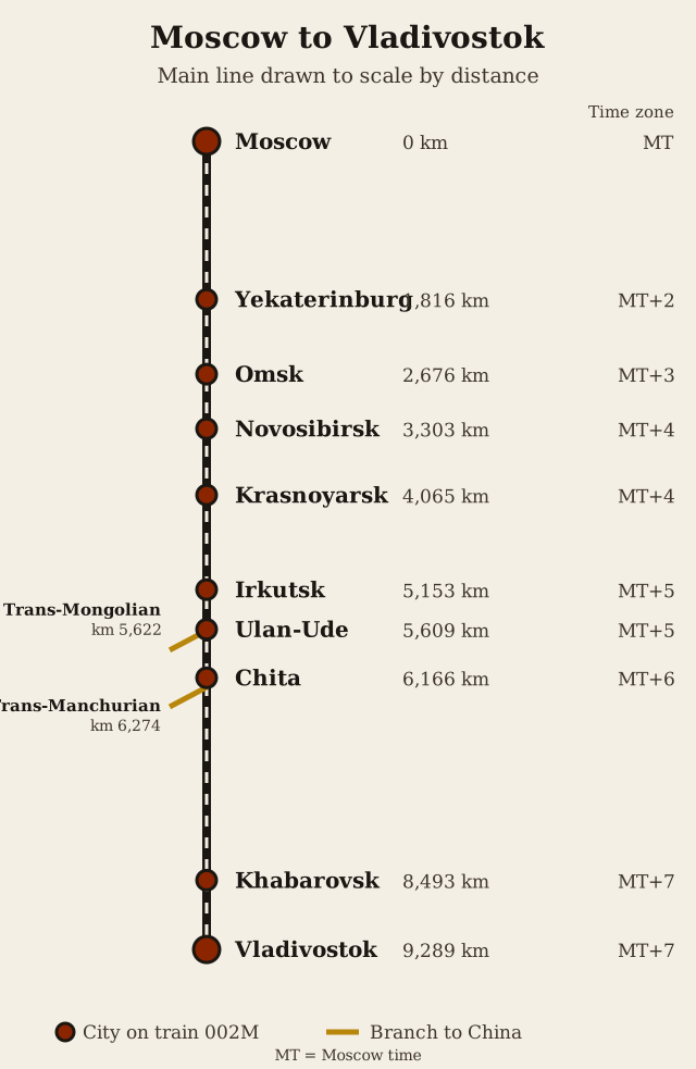
The main route leaves Moscow heading northeast, then turns east across the Volga and climbs into the Ural Mountains. It reaches Yekaterinburg, the first big city in Asia, at kilometre 1,816. From there the line crosses the flat West Siberian Plain through Tyumen and Omsk to Novosibirsk on the Ob River, now the largest city in Siberia and the junction for the Turkestan-Siberia railway to Central Asia.

East of Novosibirsk the country turns hillier. The line crosses the Yenisei at Krasnoyarsk, meets the Baikal-Amur Mainline at Taishet and reaches Irkutsk near the southern tip of Lake Baikal. It then follows the lake's southern shore to Ulan-Ude, where the Trans-Mongolian branch turns south. After Chita the railway crosses the Yablonovy Mountains; its highest point, at Yablonovy pass, sits at 1,070 m (3,510 ft). The long final stretch bends along the Amur River to Khabarovsk, then runs south to Vladivostok, where a marker at kilometre 9,288 stands by the station platform.
The figures below come from the schedule of train No. 002M, which runs the whole route. Time zones are counted from Moscow time (MT). By the time a passenger reaches Vladivostok, local clocks are seven hours ahead of Moscow.
Trans-Siberian Railway route table
| City | Distance from Moscow | Time on train 002M | Time zone |
|---|---|---|---|
| Moscow (Yaroslavsky) | 0 km | Departure | MT |
| Yekaterinburg | 1,816 km (1,128 mi) | 1 day 2 hours | MT+2 |
| Omsk | 2,676 km (1,663 mi) | 1 day 14 hours | MT+3 |
| Novosibirsk | 3,303 km (2,052 mi) | 1 day 22 hours | MT+4 |
| Krasnoyarsk | 4,065 km (2,526 mi) | 2 days 11 hours | MT+4 |
| Irkutsk | 5,153 km (3,202 mi) | 3 days 4 hours | MT+5 |
| Ulan-Ude | 5,609 km (3,485 mi) | 3 days 12 hours | MT+5 |
| Chita | 6,166 km (3,831 mi) | 3 days 22 hours | MT+6 |
| Khabarovsk | 8,493 km (5,277 mi) | 5 days 15 hours | MT+7 |
| Vladivostok | 9,289 km (5,772 mi) | 6 days 4 hours | MT+7 |
Two junctions matter for the branches. The Trans-Mongolian line leaves the main line just past Ulan-Ude, at kilometre 5,622. The Trans-Manchurian line leaves at Tarskaya, east of Chita, at kilometre 6,274.
Building the line, 1891 to 1916
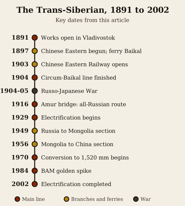
On 9 March 1891 the Russian government announced in an imperial rescript that it would build a railway across Siberia. On 19 May that year Tsarevich Nicholas, later Tsar Nicholas II, opened the works in Vladivostok. Crews then built from both ends and from several points in between, so the line grew as a chain of separate sections rather than one long advancing railhead.
To save money and avoid disputes with landowners, the planners laid the track outside the existing towns rather than through them. Tomsk is the best known casualty: the line crossed the Ob about 70 km to the south, at the settlement that grew into Novosibirsk, and Tomsk got only a dead-end branch.
Lake Baikal was the biggest obstacle. The lake is more than 640 km (398 mi) long and more than 1,600 m deep, and for years the railway simply stopped on either shore. The icebreaking train ferry Baikal, built in 1897, carried whole trains across in about four hours, helped by a smaller ferry, the Angara. Both were built in Newcastle upon Tyne, taken apart, shipped in pieces and bolted back together at a lakeside yard. In winter, sleighs moved passengers and freight over the ice. The Circum-Baikal Railway along the lake's southern edge was finished in 1904 and replaced the ferries, though both ships were kept in reserve until 1916 because the new line suffered rockfalls. The Angara survives as a museum ship at Irkutsk.

The early railway was built cheaply. It was single track with occasional passing loops, light rails that broke easily, thin ballast and wooden bridges that rotted. In the Russo-Japanese War of 1904 to 1905 that mattered: trains had to wait in sidings for traffic coming the other way, which limited how many troops and supplies Russia could move east. Historians count the line's limits as one reason for Russia's defeat. Upgrades came after the construction period: later decades brought double track and heavier rails, and electrification, begun in 1929 and completed in 2002, allowed trains of up to 6,000 tonnes.

Russia's broad track gauge
The Trans-Siberian was built to Russia's broad gauge, which goes back to the Saint Petersburg to Moscow railway of the 1840s. That line used 1,524 mm (5 ft), the gauge recommended by the American engineer George Washington Whistler: cheaper to build than a 6 ft gauge and cheaper to maintain than the 1,435 mm standard gauge used in Britain and most of Europe. Russia kept the wider gauge as its national standard.
In the late 1960s the Soviet Union redefined its gauge as 1,520 mm, a slightly tighter spacing, and converted its track between 1970 and the early 1990s. Today the Trans-Siberian runs on 1,520 mm. The difference from China's standard gauge is why trains on the Manchurian and Mongolian branches change bogies, or passengers change trains, at the border. Our track gauge guide covers how the world's gauges came about.

The Trans-Manchurian route (Chinese Eastern Railway)
Before the Amur line existed, the quickest way to reach Vladivostok was a shortcut through China. The Chinese Eastern Railway left the Russian line near Chita, crossed northern Manchuria through Harbin and rejoined Russian territory on the way to Vladivostok. Construction began on 16 August 1897, and the line officially opened on 1 June 1903. With the Circum-Baikal section done in 1904, Russia had a continuous railway from Europe to the Pacific, but part of it ran on Chinese soil.

The Chinese Eastern Railway had three branches. After the Soviet Union returned the railway to China in 1952, the western branch became the Harbin to Manzhouli Railway, the eastern branch the Harbin to Suifenhe Railway, and the southern branch, which ran down to Port Arthur, part of the Beijing to Harbin Railway. As of 2020, the Trans-Manchurian route used the western branch: Moscow to Beijing trains left the main line at Tarskaya, crossed into China at Zabaykalsk and Manzhouli, and ran on through Harbin.
Russia's defeat by Japan in 1905 showed the risk of relying on a line through Manchuria. The answer was the Amur Railway, an all-Russian route along the north bank of the Amur River. It was completed in 1916, when the bridge over the Amur at Khabarovsk opened, and from then on a train could run from Petrograd to Vladivostok without leaving Russian territory.
The Trans-Mongolian route
The Trans-Mongolian line follows the Trans-Siberian as far as Ulan-Ude on the eastern side of Lake Baikal, then heads south through Mongolia. It crosses the border at Naushki and Sükhbaatar, passes through Ulaanbaatar, crosses the Gobi Desert and enters China at Erenhot, ending at Ulanqab in Inner Mongolia. From there trains continue to Beijing.
The line came in two stages. The Russia to Mongolia section was completed in November 1949, and the Mongolia to China section was opened by the Inner Mongolian leader Ulanhu on 1 January 1956. The route measures 2,215 km (1,376 mi), of which 1,110 km (690 mi) lie inside Mongolia. For many travellers this is the version of the Trans-Siberian they ride, since it links three capitals: Moscow, Ulaanbaatar and Beijing.

The Baikal-Amur Mainline
The Baikal-Amur Mainline, or BAM, is a second line across eastern Siberia, built to give the Soviet Union another route to the Pacific further from the Chinese border. It leaves the Trans-Siberian at Taishet, passes north of Lake Baikal and runs for more than 2,000 miles, roughly 400 miles north of the older line, to Sovetskaya Gavan on the Pacific coast.
The BAM was one of the great Soviet construction projects of the 1970s and 1980s, built across permafrost, mountain ranges and wide rivers. A symbolic golden spike was driven in 1984, though less than a third of the line was actually working at that point, and full operation came years later.

The Trans-Siberian story is a story of choices any rail builder faces: the cheap route or the safe one, a shortcut through someone else's land or a longer line on your own. Rails & Rivals, our game on Steam, is a turn-based railroad strategy board game for 2 to 6 players: each player runs a rail company, lays track across a hex map and carries goods between cities, and the wealthiest company wins. The how to play page has the rules.
Keep reading
Sources
- Trans-Siberian Railway (Engineering and Technology History Wiki (IEEE))
- Trans-Siberian Railway - General Information (Structurae)
- The Baikal-Amur Mainline (Michigan State University - Soviet History)
- Completion of the Trans-Siberian Railroad (EBSCO Research Starters)
- Trans-Siberian Railway (Wikipedia)
- History of rail transport in Russia (Wikipedia)
- 5 ft and 1520 mm gauge railways (Wikipedia)
- Trans-Mongolian Railway (Wikipedia)
- Chinese Eastern Railway (Wikipedia)